 Nautical miles: 96.
Time under way: 19 hours and 28 minutes.
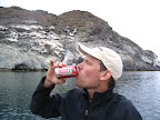
Cans of Tecate: 15.
Cans of Pacifico: 11.
Odds of seeing rare painted chuckwallas: Who knows?!
 One of the great things about having a kid aboard is that it motivates you to do things that otherwise you’d dismiss with “Nah, too much hassle!” When leaving San Carlos in early March, the temptation is to shoot Southwest across the Sea of Cortez to Santa Rosalia, because the wind generally comes from the Northwest. We were interested in seeing the Midriff Islands, but the largest of them, Isla Tiburon, lies about 85 miles Northwest of San Carlos. This means that to get there, we’d (presumably) have to go right into the wind. And you know Capn Smooth Ride doesn’t like that one bit!
 But then we read about the rare painted chuckwallas on Isla San Esteban. These large lizards (think of a yellow and black iguana) live on only three small islands in the whole world! We didn’t know if we’d get to see them, but then we imagined Koiya leading the chuckwalla scouting party. Prevailing winds be damned, we had some homeschooling to do! (And as Todd pointed out, we’re going to have to go waaay farther upwind to get the boat home….)
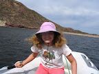
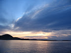
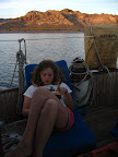 Our first stop was Bahia San Pedro, a little bay just 15 miles Northwest of San Carlos. With no wind and calm seas, we motored there in less than 3 hours. Though San Pedro is frequented by panga fishermen, who clean their catch on shore and sometimes camp overnight, there is no town or houses, so it feels remote and peaceful. We dinghied ashore to explore the beach, then got down to the business of cruising: reading, eating, drinking, listening to music, and watching the colors change as the sun moved across the sky.
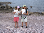
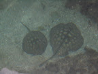
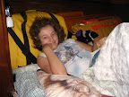
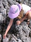 A short hike takes you to another little bay with tidepools, so one day we packed a picnic lunch and went ashore for some tidepooling. For me, the best part of tidepooling is seeing Koiya so animated. She buzzes about, constantly calling, “Come see this fish!” or “I caught a shrimp!”
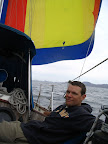 The following morning we got an early start and planned to hop up to another bay about 15 miles further up the coast. Surprisingly, we had a wind from the Southwest! We sailed under the spinnaker for a few hours, and then switched to the main and jib. The wind was holding, so we decided to go for Isla Tiburon, about 70 miles away.
 We arrived at Isla Tiburon around 9:30 that night, and had a great night at anchor in Bahia de Las Cruces. The next morning we had a great sail to Isla San Esteban, with 15-20 knot winds and small seas. I remarked that was like sailing in San Francisco Bay, and Koiya said, “Only warmer!”
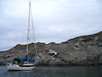
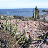
Though the anchorage on the East side of Isla San Esteban is not ideal (you get wind from the East, swells from the North, and there are some large rocks to avoid), the water is a beautiful turquoise, frequented by curious sea lions. And ashore, there is easy access to an arroyo that extends far into the island, making for great hiking. The quest for chuckwallas was on!
 Within a few minutes of landing the dinghy, Koiya found a dead chuckwalla. Well, at least we knew they were around! After a group huddle and a team cry of “Chuuuuck-Walla!”, we scurried up a little gully, onto a rocky plateau. We were in “stealth mode”, whispering and trying to walk quietly, but that’s kind of hard to do when you’re slipping on rocks and gravel, in between scratching yourself on various desert plants.
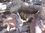 Suddenly Koiya shouted, “I saw one!” “Alive?” I asked. “Yes!” she cried. “Over here! Oh, it’s so FAT!” The poor lizard was trying to hide under a bush that was woefully inadequate for its considerable size: about 2 feet long and eight inches wide! It was a splotchy black and orangish color.
Though they are shy and quickly retreat to their dens or other hiding places, throughout our hike we saw about 10 or so, of varying size and color. On a picturesque desert isle out in the middle of the Sea of Cortez, the hunt alone was a lot of fun. Actually seeing those fabulous reptiles in the wild was a thrill we’ll always treasure! They reminded us of our dear bearded dragon, Komodio.
 After Isla San Esteban, we made another short hop to Isla Salsipuedes. “Salsa Puedes?” asked Toro. “I like salsa! Is that kinda like a tomatillo salsa?” I graciously offered to expand his limited grasp of Spanish. “Actually it means ‘Leave if you can’,” I explained patiently, “as sal is the command form of the verb salir…” “Or maybe it is more like a chipotle?” interrupted Toro. “I want to go to Isla Guacamole!” chimed Koiya. “I’ll bring the chips!” cried Toro. Their high-five concluded the Spanish lesson for the day.
 We had a bit of excitement getting to Salsipuedes. One cruising guidebook said that it was possible to save a few miles by passing between Salsipuedes and Isla Animas, as long as you stayed very close to Salsipuedes. We followed the advised course of 28 degrees, 43 minutes, expecting to see depths of 28 feet. “Are you sure about this?” I asked. “Seems like we’re headed right at the island.” “It’s ok,” replied Capn Confidence, “When we get closer, I’ll go up on the bow.” “And do what?” I asked, “Squawk like a chicken? How is that going to help?” In reply he did a little chicken dance.
 As we got closer, we could see large rocks rising up through the clear water. All of a sudden, the depth finder showed 12 feet! “Should I bail?” I asked. Without missing a beat, totally calm and without intonation, Toro said, “Yep.” I had the boat halfway around as he gave the order, “Hard right!”
Then he did indeed run to the bow, squawking back, “Depth! What’s our depth?! What is it now?!”
We were soon back in deep water. “So,” I said. “North around the island then?”
“North sounds good!” replied Capn Chicken.
 The same cruising guidebook gave the coordinates of a dangerous pinnacle rock near the anchorage we were headed to. We arrived in a pretty but narrow little cove, careful to avoid the given location of the pinnacle. Then Capn GPS and his sidekick Koiya set out in the dinghy to find the feared pinnacle. There was nothing there! Could someone have hit it and destroyed it? Could Capn GPS have entered the coordinates incorrectly? We consulted the guidebook again and realized a couple of things: (1) We were not anchored in the cove we had meant to be in, but in the one “next door”; (2) The coordinates given for the pinnacle didn’t match the location drawn on the map.
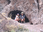
 So the three of us set out in the dinghy again, to explore the many little sea caves, with their starfish, urchins, and red crabs. On the way back to the boat we rowed around the area where we thought the map indicated the pinnacle was. “It’s getting shallower!” cried Koiya from the bow. Sure enough, there it was: a HUGE rock rising to within a few feet of the surface of the water, right in the path you would take if you were headed to the anchorage we had meant to go to! Todd noted the correct coordinates on the GPS, and we all breathed a sigh of relief that we had missed it on the way in!
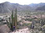
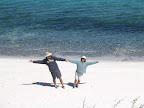
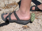 The next day, we meant to head North to Bahia de Los Angeles, but soon after we started out, the wind picked up and the seas got bigger. Plans be damned, we had to go with the prevailing winds! So we turned around and headed to Bahia San Francisquito, which turned out to be, as Toro describes it, “A little slice of heaven.” The bright white sand beach is regularly patrolled by coyotes, who howl at dawn and dusk. Hiking ashore we saw one coyote, a jackrabbit, lots of quick lizards, and pretty wildflowers. And Koiya had a close encounter with a cactus!
We would have liked to stay longer, but as we were down to one potato and three limes (not to mention 4 Pacificos), it was time to get some fresh provisions. So after a wild overnight ride, we’re now in Santa Rosalia, in Baja California Sur. See all of our Midriff Island and San Francisquito pictures here:
 |
| 20090311Midriff |
Although it would probably be a shame I wonder if anyone with Chuck E Cheese has ever considered putting lizards on a pizza. Then you could have a Chuck E. Cheese Chuckwalla special.